History
Geological
The Waitaki District’s spectacular scenery owes much to a chain of natural events which have created unique landscapes and natural features. From gold bearing rivers and rocks in the south to the colossal spherical boulders at Moeraki up to the rare pillow lava around Oamaru and inland along limestone escarpments, the district’s geology offers unique site seeing and recreational opportunities.
Ancient marine mammals became fossilised millions of years ago. As the land was uplifted by massive tectonic forces these limestone deposits became the hills and valleys of our district.
The mountain wall which isolates the district from the rest of the Otago province runs North West from the sea to Shag Point. The costal portion is known as the Horse Range and consists of low, steep hills but inland the tops of the Kakanui Ranges exceed five thousand feet. The range forks beyond Danseys Pass. One branch sweeps around towards the Waitaki River; on it stands Mt. Domett, an impressive peak that dominates the North Otago landscape. The left branch formed by the Hawkduns and a series of other ranges run up to the Southern Alps.
At Kurow a gorge divides the district into two parts. Above this point is a chain of upland basins resplendent with stark mountains and broad interior valleys. This high country area is a land of contrasts where vivid blue skies and turquoise lakes frame scorched brown mountain sides; where summers are long and hot and winters are hard and cold.
Below Kurow, the district forms a triangle with its corners at Kurow, the Waitaki River Mouth and Shag Point in the south. A series of mountains and foot hills gradually give way to rolling downlands. A belt of plain lies along the Waitaki River widening as it reaches the coast at Pukeuri.
Underlying much of the land is a broad belt of limestone that runs from Kakanui to Otekaike. Outcrops in the form of flat shelves, terraces or cliffs, white to grey or pale brown in colour, have been weathered into fantastic formations at areas such as Elephant Rocks and give the local landscape a special character unequalled elsewhere.
Maori-Pre European
About 850A.D. the Waitaha people came and settled at the Waitaki River mouth. These nomadic people led by Rakaihautu often traded with North Island Iwi supplying goods such as the flesh of moa and the oil from taramea (Spear grass).
At about 1550A.D, the Kaitimamoe people, and later in 1685, the Kai Tahu people moved to the valley from the North Island. One of the resources they treasured was pounamu (greenstone).
In 1877, Te Maiharoa, the last great Tohuka (learned man) and Rangatira of Waitaha decent led the people in support of a Southern Maori claim that the inland country was not included in the sale of Otago. Te Maiharoa also established a school at the Waitaki River mouth where he taught astronomy, mythology and history. His descendants continue to live in the area today.
European
The Maori people were helpful to early Europeans. In 1844, Edward Shortland met the Rangatira Huru Huru who drew him a map. Shortland was the first European to describe the Waitaki Plains writing that the soil was “stony and baron” and suited to sheep grazing. Early European settlers followed his suggestion. They also practiced whaling and grew crops such as wheat and barley.
While Oamaru’s early wealth was founded on gold, it was the prosperity of the agricultural sector that provided the impetus for a thriving commercial port and harbour area. Alongside these industries, business interests flourished.
The first immigrant ship arrived at Port Chalmers in 1848. Others hardy souls followed with some opting to make the journey north and settle in the Waitaki. A pastoral run extending from the sea at Oamaru inland to Waiareka was applied for and stocked by Hugh Robison in 1853. In the same year, Robison made the first modest European dwelling from cabbage tree stems and clay on Itchen Street.
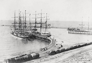
Oamaru’s rich maritime history is immortalised at Oamaru Harbour. Although commercial usage has dwindled over time, the original structures remain intact and the area is undergoing a revival with plans underway to inject a new lease of life into the harbourside area.
Copies of a fantastic 10 minute DVD "Another Great Story of Pioneering New Zealand", detailing the history of the development of the township of Oamaru, are available from the Visitor Information Centre (i-SITE), 1 Thames Street, Oamaru. Cost is NZ$5 per copy plus postage.
For more info: [email protected]